Posted by make up on 11:36 PM
Posted by make up on 8:45 PM

The Coban Rondo waterfall (we called The Wana Wisata Air Terjun Coban Rondo) is a beautiful waterfall and gives peacefull impression. The experiences never forget is The way to the waterfall, on the right and left side you can see the beautiful of aligment cypress and pine trees. The coban rondo waterfall was located 12 km from the Batu City, or to be precise in the Pandansari Village. Pujon. In the coban rondo you will be experienced by a waterfall with the height 60 m.

The Wana Wisata Air Terjun Coban Rondo region was the region that most was easy to be followed. The road to enter towards the location has been asphalted, so as really facilitated tourists if wanting to visit this waterfall. Around the waterfall of Coban Rondo, was filled pine trees and the mountain casuarina, made the atmosphere in this tourist attraction feel like cool. From this area , you can see also the panorama of Batu town.
The Coban Rondo waterfall kept the unique legend. It seems, under the waterfall was gotten the residence cave of a woman was named Dewi Anjarwati. Her husband, Raden Baron Kusuma fought against Joko Lelono, the young man who was interested with the beauty of Dewi Anjarwati and will kidnap her. Raden Baron was killed in the battle and the wife him was hidden in the cave by her servant. Therefore this place was given by the name of the Coban Rondo Waterfall (the widow’s waterfall).
Posted by make up on 3:15 AM
 Can you imagine being charged for using the toilets on a flight?
 - What is your opinion on this?
- Can you make any sense of this policy?I will be waiting for your comments
Posted by make up on 9:27 AM
North of Bali tour
Famous with Dolphin or Ikan Lumba – lumba in bahasa Indonesia
Swimming with Dolphin, it costly 1.000.000 IDR ( 100 US$ ) per one person. The rate would be change some time
09.00 am Leave the hotel lobby, two hours drive up to the bedugul area, a cold situation surrounded by the mountain and viewing to the very cold lake for your Buffy lunch as well as the temple be hind the lake if you want to see. Than a twin lakes would be very beautiful for the picture
- It is the time to the dolphin. It would take about one and half hour to drive
- As soon as arrive is the time for you to enjoy the main tour
- Back to the hotel you may choice the same way or the other way to know the different view.
- Would be late at night for your dinner or get some where on the way to the hotel
Please Contact : I wayan berate. Mobile +628123922641
Posted by make up on 9:20 AM

Volcano tour such as Batur volcano and Batur lake
While you may having lunch, you may enjoy the both beautiful view
08.30 am Leave the hotel lobby for the traditional Balinese barong dance at 09.00 am
09.00 am The traditional Balinese barong dance or Kris dane. Kris is a sharp holly knife
- Which almost all of the Balinese family has to have at home.
- Gold and silver smith of Uc silver or Celuk village.
- Balinese painter and the painting of the all over the 8 Bali’s regencies at Ubud district.
- Balinese wood carver of Ida bagus marka at kemenuh village.
- Straight away to the volcano.
- Free Bali coffee or tea at the coffee plantation.
- Temple of Batuan village. Note : for the ladies and women’s on period or Menstruation are not allowed to enter the temple as well as if there some body has passed away in the family till 42 days.
- Kuta would be the choice to be explored, while you may have your sea food diner there or direct to the Jimbaran bay sea food café.
- It is the time to be back to the hotel.
Please Contact Bali Tours Guide
I wayan berata. Mobile +628123922641
Posted by make up on 11:24 PM
Posted by make up on 9:21 PM

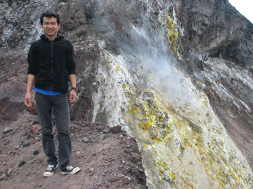
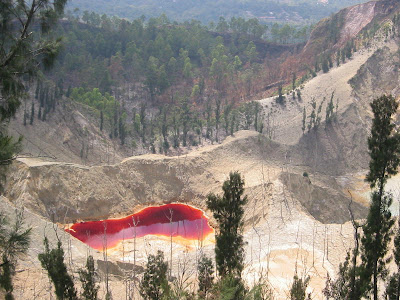
Kelimutu is a
volcano, close to the town of Moni in central
Flores Island of
Indonesia containing three summit
crater lakes of varying colors. Tiwu Ata Mbupu (Lake of Old People) is usually blue and is the westernmost of the three lakes. The other two lakes, Tiwu Nuwa Muri Koo Fai (Lake of Young Men and Maidens) and Tiwu Ata Polo (Bewitched or Enchanted Lake) are separated by a shared crater wall and are typically green or red in color, respectively. The lake colors do vary on a periodic basis. Subaqueous
fumaroles are the probable cause of active
upwelling that occurs at the two eastern lakes.


The lake have been a source of minor
phreatic eruptions in historical time. The summit of the compound 1639-m-high Kelimutu volcano is elongated two km in a WNW-ESE direction; the older
cones of Kelido and Kelibara are located respectively three km to the north and two km to the south. The scenic lakes are a popular
tourist destination.
Posted by make up on 4:01 PM
Posted by make up on 12:22 AM
Posted by make up on 5:28 PM
Posted by make up on 9:02 PM
Posted by make up on 1:23 PM

Gedung Sate Bandung is the first building that uses concrete bony construction, is also building institutions of governance Dutch Colonial Center. Called Gedung Sate, the roof-shaped ornaments thrust sate. Now, this building became the center pemerintahah Governor of West Java. Designed and built in 1920, by architect J. Gerber.
Building on the north, there is a field Gasibu and People's Struggle Monument. Area Gasibu People's Struggle Monument and will look very busy on Sunday, because in the two locations near this always be a place for sport in the morning. In addition to use as sports facilities, both locations are often used as places of music, art and culture and other activities.
Posted by make up on 1:20 PM


You will not feel tired because the pampered along the way with the beautiful scenery from the mountain slopes with dense forest and natural hills and plantations such as rubber, tea, and cocoa trees (cocoa).
Scenic waterfalls Neglasari you will find beauty when you break on the way. Located at the top of the mountain, and we can enjoy them from the tea garden areas extend Neglasari knowledgeable in the area. Truly stunning scenery.
Sesampainya there are some beaches you can visit one at the beach, among Santolo, Heulang Unfortunately, Cijeruk Indah Beach, Rancabuaya, and Paintai Pameungpeuk.
santolo coast or Coastal cilaunteureun the most visited tourist Santolo the beach that is located about 7 km from the small town, Pameungpeuk. This beach is the gathering place of the traditional fishermen as the main search-eyed fish in the Ocean Hindia.Anda can also rent a boat for the surrounding ocean, so you can enjoy the beautiful beach panorama from the sea.
Green sea Pameungpeuk Garut average despite the natural enggak so we need to worry with the facilities that you need because there we can find a wide range of food, cendramata from clothing accessories to the beach, accommodation is also available if we want to spend the night there.
That is not less important where we can find the location of eight satellites (the National Institute Antarariksa) was launched, because near the coast is a research center launch eight satellites. Still more that needs to be known about the natural wealth of Garut Pameungpeuk not touchable by foreign and local tourists. IndofamilyTravel.
Posted by make up on 1:07 PM

This mountain, 2064 meters high above sea level. Located in North Bandung Area (units), separated by a large valley with Mount Tangkubanparahu. Burangrang including parasites old volcano, so that has valleys and in the slice with a steep slope. In Sangkuriang legend, the mountain was of branches (rangrang) Sangkuriang tree used to make boats. Will be angry at the failure, Sangkuriang kick the boat up to reincarnate as Mount Tangkubanparahu, while the tree branches and blossom as the Mount Burangrang.
Climbing to the mountain this can be done from the Bandung and Purwakarta. If the climb from Bandung, we can select multiple channels, including through the Yellow Sands, Legok Haji Lawang Wind or path. Path-the path that consists of paths that split up in the forest and common finish in two to three hours travel. Be careful, a lot of dangerous terrain and thick fog can appear hinder your view.
Burangrang peak marked with a monument (a point of height). From the peak, if the weather is not sunny and hazy, you can see the stunning scenery to the Situ Lembang only visible as a small pool in the middle of the basin is surrounded mountains. Basin is not used to the point of bursting a very broad (kaldera) from the ancient volcano called Gunung Sunda. So, mountain fortify Situ Lembang crater wall is generated by a tremendous explosion. You have to enjoy them because what you see is a rare scene that is not visible to everyone. Enjoy while you breathe in fresh oxygen mountains.
Posted by make up on 1:05 PM

Cikuray identical with a giant cone is one of the mountain, located in the southern city of Garut in West Java. Mount is included in this group of young mountain mountains that are categorized as non-active. Although the mountain is beautiful, but rarely include didaki and dijamah must recognize the popularity and other mountains like Mount Gede and Mount Pangrango CIREMAY. To reach the location of climbing, climber can start from Cilawu, next to the plantation Dayeuh Manggung, before starting to climb this mountain peak. From the area climber can find a tower high enough (TVRI) that later can be a way (guidelines) in a trip to the summit.
As the characteristics of the mountains that form memilikik like this, the water flow will be found difficult or even not at all in the journey to the top of the mountain, and springs in the mountains this is only found in the bottom (or Cilawu Dayeuh Manggung ). Therefore, the climber should bring an adequate supply of water.
To achieve a high mountain peak reaches 2821 meters above sea level, the need of the time for 7 to 12 hours for normal time and at a certain time should diasarankan climber to rest in order to maintain the condition and energy. Because the climbing routes that are still rarely included dijamah people, then we will of the forest are a natural and beautiful, but needs to be remembered by every climber in that during the journey to the top we will find some way of branching, because the instructions to the mountain peak is not clearly as well as Mount Gede who have to use the arrow to reach the peak, the gang leader should always extra careful in taking path climbing because the climber does not a little misguided because in determining the correct path that will be passed in the ascent.
Forest is there in the mountains this is one of the forest which is perfect, because in some parts of the valley slope or almost never dijamah by humans, as evidenced when the author was trying to open a new path, the author does not find ex-ex-exploitation of human beings, and even search kayupun never reach the location.
It was evident from the absence of any trace in the form of a discount department paths, both the top and down the peak. And the situation is different with most of the mountain in Central Java. Mountains in Central Java than Mount Slamet (3428 M) has experienced large-scale exploitation of the forest so as buffer areas around water sources and clean for people to be disturbed even in some places almost found the water flow.
Each climber will feel happy after reaching the peak, as in climbing to the top of Mount Cikurai this. Climber satisfied after reaching the peak. Especially cikurai peak, climber will be the scene are probably different from the top of the mountain scenery on the other, because if we stand at the top of the mountain is more or less the extent of "football field", the view is very clear we will see the surrounding mountains, as there is no any trees or buildings that obstruct our view. Therefore, the climber should culminate in the early days when the sunrise, the landscape probably will never be forgotten.
After climbing the peak is complete, the climber is given the option to decline path. Climber can descend down to the Cikajang or skip lines when the climber early start climbing.
To achieve Cikuray can be increased with the vehicle from the public or from Tasikmalaya Bandung toward terminal Guntur. From the city terminal, we can ride the city transportation department number 06 Garut - Cilawu and down in the portal nusantara tea plantation (PTPN) VIII or Dayeuh Manggung. From here, proceed with the journey on foot around 10 km to the station several television stations as a starting point climb. If you want fast, we can rent motorcycles at Rp.30 ribu per person.
Or 2 can use another path climbing commonplace use (Cikajang & Bayongbong). The three lines offer a very interesting field with characteristics of each. Channel bayongbong path is the most precipitous, but it can quickly reach the peak.
Posted by make up on 1:01 PM


Mount Ceremai have a distinctive feature when compared to other mountains on the island of Java. This mountain is located far apart from the high mountains and other side is the Java Sea.
Travel to G. Ceremai can be started from the terminal Cirebon, Kuningan ride the bus and go down in Cilimus. From Cilimus we connect with Colt vehicle or motorcycles to the village Linggarjati.
Linggarjati in the village, we can stay in the Hotel Linggarjati. From the hotel Linggarjati we travel forward through the manuscript to the building until around West Central Village Linggarjati. Here we find a former climber or precisely interpreter lock, which is called a pack of Ahmad, who because of age, he is now experiencing vision disturbances.
From here walk straight and we'll find pine forests, then we will arrive at the fork, called Cibunar. In this place we can build a tent because the available water. Travel resumed by selecting the way to the left toward the mountain peak Ciremai. 5 hours later we will find a large stone, the location made the rest POS called Watu Lingga.
Lingga from the top (crater) adopted in the 2-3 hour drive through the forest and rocklike cadas. From the peak to the right we go to the crater sulfur takes about 1 hour trip. To take a peak around 2 ½ hours, we can see the interesting Majalengka towards the city, Bandung, Java Sea and the other. Down from the peak to the village Linggarjati be in 3-4 jam.Jalur climbing
As the highest mountain in West Java, Mount Ciremai is one of the main climb and the young generation of nature lovers and the average visits per year is estimated to reach 15,000 people. There are three climbing routes, namely route Linggarjati and Palutungan in Kab. Brass and Apuy path in Kab. Majalengka.
Nature Tourism
Panorama Mountain natural Ciremai variatif and quite unique and have a high value such as Estetika Pesona Ciremai dipuncak sunrise, the beautiful natural forests, the beauty of Water Terjun in the valley, bathing and natural hot springs. Nature of tourism in the region in the Kuningan area, among other
1. Valley Cilengkrang, Curug sawer, Curug belt (Pajambon)
2. Pond mussel and swift water Paniis (Pasawahan)
3. Curug daughter (Cigugur)
While in the region Majalengka among others:
1. Curug Sawer (Argapura)
2. Curug Tonjong and panoramic natural Sadarehe (Rajagaluh)
Culture Tourism
For the pilgrims / cultural tourists, the area TNGC many places that have high historical value and dikeramatkan by the local community are: there Sangiang (Banjaran), Mt shoots (Argapura), Sumur Seven (Cibulan), Sumur Cikayan (Pasawahan), and there Ayu Latitude (Mandirancan).
Tourism Education
For the pilgrims / cultural tourists, the area TNGC many places that have high historical value and dikeramatkan by the local community are: there Sangiang (Banjaran), Mt shoots (Argapura), Sumur Seven (Cibulan), Sumur Cikayan (Pasawahan), and there Ayu Latitude (Mandirancan).


 Kelimutu is a volcano, close to the town of Moni in central Flores Island of Indonesia containing three summit crater lakes of varying colors. Tiwu Ata Mbupu (Lake of Old People) is usually blue and is the westernmost of the three lakes. The other two lakes, Tiwu Nuwa Muri Koo Fai (Lake of Young Men and Maidens) and Tiwu Ata Polo (Bewitched or Enchanted Lake) are separated by a shared crater wall and are typically green or red in color, respectively. The lake colors do vary on a periodic basis. Subaqueous fumaroles are the probable cause of active upwelling that occurs at the two eastern lakes.

.jpg)
 Here are some of my students´ podcasts related to topics linked to tourism: reasons to travel, opinions on tipping, flying, etc. These podcasts are produced by my students through a voice forum in which they participate on a regular basis. Thanks to all of them for their participation and their interesting opinions.


